In reviewing a map of the area near our base camp, we discovered a place referred to as Utah’s “Little Grand Canyon”, along the San Rafael River. So we set out to check out that site. Along the way we found other interesting places and sites. This post and following ones will showcase our finds.
The drive to the “Little Grand Canyon” was along maintained gravel backroads, although most of the roadways were washboarded, rocky and rough, but scenic for long stretches with exposed geological features.
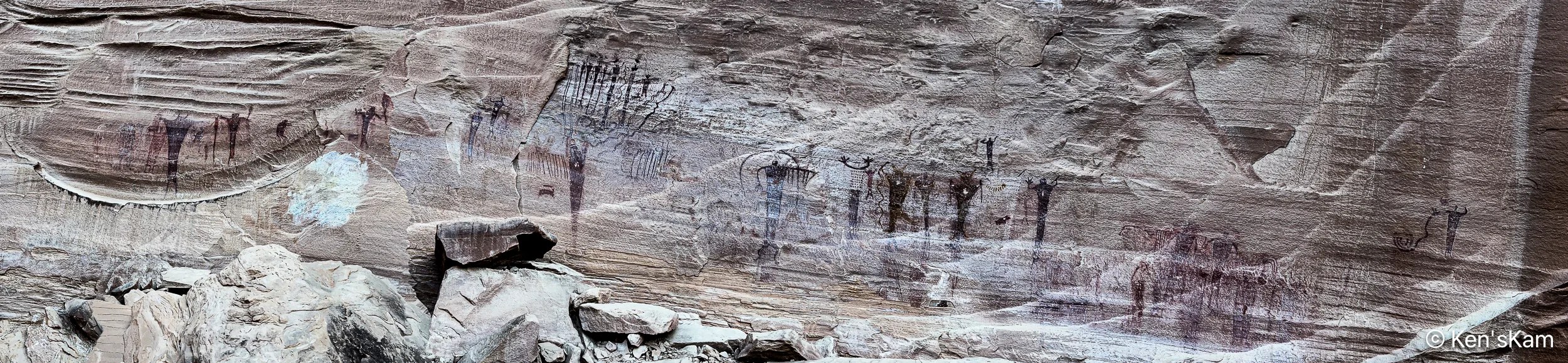
There are a couple of easily accessible Native American artwork panels on rock faces along this drive. One requires walking up a slight incline to reach, but the most impressive one, Buckhorn Wash Petroglyph Panel, has a large parking lot and is literally right at the edge of the parking lot.
The Buckhorn Wash Petroglyph panel is long. Much longer than this panorama might indicate. I made this panorama with my iPhone by walking fast from one end of the panel to the other, trying not to trip and fall on the rocky, uneven surface. I was inspired to do this, after watching my son do it. Otherwise, I might never have thought to do a pano in this manner.
The following images are shots of small portions of the panel, showing details of some of the pictographs.
There are a number of signs placed in front of this panel with information and questions about what these images mean and how newer cultures came along and modified the older pictographs. And, yes, even modern day vandalism. In fact much damage to this panel was partially repaired in 1995.
Information Sign at Buckhorn Wash Petroglyph Panel
Please refrain from defacing such ancient records. These are already fading away due to natural weathering. Don’t accelerate the loss.
After photographing wildflower scenes around my campsite, I left the campsite to travel into Badlands National Park to scout locations for golden hour photography. But first, I drove around a little in the large public land area, where I was camped to get a better feel for the area and scout other possible campsites, in case my prefered location was again taken or the site I occupied on my first night here was taken, when I returned in the evening.
There are numerous road trails through this area, which is popular with off-road vehicle riders, who create their own trails with their dirt bikes, 4 wheelers and other vehicles. I traveled into the area a bit, but did not take time to fully explore the area, after I was satisfied that it would be no problem to easily find numerous suitable places to overnight here.
I parked along one of the trails on my way out, hiked up to the top of one of the many hills in this area and captured this pano:
There is a gravel road that leads from the small town of Interior, SD into Badlands NP, which I take as a short cut into the park, rather than following the highway to a main entrance. There is a sign indicating when one is entering the park on this backroad, but no entry station. The sign does inform that a permit or fee is required to be in the park, so anyone in the park might be asked by a ranger to show proof of fee payment or other permit. I have a Senior Pass, one of the few benefits of old age, so I never worry about having to show proof that I can be in a National Park.
I stopped on this gravel backroad to shoot a few images of the Badland features in the distance that appear to “erupt” out of the flat land in the foreground.
It was a mostly heavily overcast day with periodic light rain. I stopped at a number of the overlooks to snap a few scouting photos with my iPhone. The dramatic clouds in the sky made for interesting photos and I probably should have taken more time to capture better quality images with my Nikon Z8 and wide angle Z14-24mm lens. The Z8 is sealed well, but keeping rain drops off of the big lens glass can be a problem and I wanted to be able to scurry about quickly, so I left the big camera and lens in my vehicle, while I scouted various locations for shooting later in the day.
With the heavy cloud cover, not much direct light fell upon the badlands features, but occasionally a little light broke through the clouds to highlight some of the rocks.
The shape of the mound of dry, cracked, gray earth in the foreground bears a similarity with the shape of the rain clouds in the sky, yet the dryness of that mound of clay contrasts with the wetness of the clouds.
Lushness and Barrenness
Lush green vegetation in the low areas contrasts with the almost barren rock in the background.
Meander
A meandering stream runs through the low area at the base of the badlands features.
More Badlands images later,
Ken
P.S. These images are best viewed on a large screen.
In early June 2025, I traveled to Badlands National Park, South Dakota. I was not completely satisfied with my photos from this awesome national park from a visit a few years ago. I had some ideas of how to get better images during this visit.
I arrived late in the day and went directly to a BLM area south of the park that I had discovered during my last visit. At that time, I was often the only camper, at least as far as I could tell, in the area.
This time there was a camper in my favorite, quick and easy access spot. So I continued along a narrow dirt trail to find another suitable overnight location. This is a large area, so there are no shortages of possible parking/camping sites, but I was no longer alone in the area. There were no other campers nearby, but I could see one or two far away on higher locations. This place has been discovered, but is still sparsely utilized.
The forecast for the next morning was for heavy overcast and I was tired after my long journey, so I decided not to get up early for sunrise photography. Rather I explored a bit in this area and photographed the local scenery with my iPhone, including blooming cacti. As I drove around the area, I began to realize how big it was. I did not even explore to the limits of the area, before leaving and driving into the park to scout potential photography locations.
More photos from scouting and exploring Valley of Fire State Park, Nevada, March of 2023.
Inside to Outside, iPhone PhotoMultiple Arches, iPhone PhotoRock of Many Windows, iPhone PhotoChecking the LCD, iPhone PhotoThrough an Arch, iPhone PhotoArch Light, iPhone PhotoPhotographic Inclination, iPhone PhotoShouldering the Load, iPhone PhotoSky View Arch, iPhone Photo
The number of arches in this area is almost unbelievable. One could spend much time here just photographing arches from inside, outside and through. I’m reminded of the Joni Mitchell song “Both Sides Now” about clouds and how it could be adapted to describe having seen arches from many sides and still not having seen all aspects of arches.
While examining a digital satellite map image of the forested area near my operational base in Indiana, I noted one area designated as a wilderness, so I decided to drive into that area and check it out.
All of the photos in this post are via my iPhone.
Almost Peak Color
I pulled off of the forest road through the Hoosier National Forest on my way to check out the Charles C. Deam Wilderness area at a camping/picnic area to look around. There were restroom facilities, shelters, picnic areas and a few visitors. I noted a hiking trail that went into the forest from here, but I did not take time to check it out. There were a few colorful trees in near peak fall color, so I made a few iPhone images, with the one above the best.
I continued down the forest roadway, spotting a number of “No Parking” signs along the way.
Steep Fine, Gentle Hillside
This roadway is narrow, so parking along it would impede traffic and probably would create a danger, since visibility over hills and around curves is limited and one could easily crash into a parked vehicle that appears suddenly in the narrow roadway. The $80 fine seems steep, but maybe necessary to discourage parking here.
I found a parking lot just off of this roadway at an old fire lookout tower that is no longer in use, but open for visitors to climb.
Descriptive Sign, Hoosier National Forest, Oct 2021
Apparently, there were farmlands in this area at one time, but those have been taken over by the forest, after this area was designated a wilderness area.
An old fire lookout tower, Hoosier National Forest, Indiana, Fall 2021
I chose to climb the 133 steps to the top to get an overview of this area. As I started up the first flight of stairs, I had second thoughts about my choice as the stairs wobbled with each step. After a brief hesitation, I continued the climb.
Note on stair rail
Near the top of the tower, I noted that someone else had the same reaction as I did to the wobbly stairs.
A view from an old lookout tower, Hoosier National Forest, Fall 2021
I shot a few iPhone photos from the observation floor of the tower. Being above treetop level, I had a good overview of the vast forest around the tower.
A view from an old lookout tower, Hoosier National Forest, Fall 2021A view from an old lookout tower, Hoosier National Forest, Fall 2021A panoramic view from an old lookout tower, Hoosier National Forest, Indiana, Fall. 2021Top flight of stairs of lookout tower
After enjoying the view, it was time to descend the “sketchy” stairs and get my feet back on firm ground.
Wilderness Marker
I saw a trailhead marker near the tower, so I walked over to check it out. I was not prepared to hike in this wilderness today, but I decided to come back another day for more exploration.
Near a trailhead into the Charles C. Deam Wilderness, Indiana, Fall 2021Information Sign, Hoosier National Forest, Indiana, Fall 2021
There was an old road beginning at the end of the tower parking lot that was blocked off with a steel gate. I walked over to take a look down the roadway and found this sign about an old cemetery that was apparently here prior to the wilderness designation. There was no indication of how far it was to the cemetery, but I decided to walk the roadway, hoping to find something interesting.
I found remnants of old structures that were mentioned in the information sign at the tower and continued to walk the roadway for awhile. I never found any indication of how far it was to the cemetery and I eventually turned back, since I did not see any noteworthy reason to continue.
A view into the Wilderness
This final image, looking into the wilderness woodland, was taken somewhere along the route.
This is continuation of the iPhone photography in Indiana antique stores during the early days of our two week fall stay in Indiana.
Old American PotteryABC’s of Photography
Older photographic equipment always gets my attention. I’m glad I do not have to use those items.
Dangerous People
Some of those pictured in this poster, seem to be misclassified as Rock and Roll musicians. After noting one such collage of these bad criminals, I began to see these more often in this area.
Shot Glasses
Bad guy entertainers may be unpopular here, but alcoholic beverage items are prominently celebrated.
Bourbon Barrel
And Bing Crosby is ok.
Bing on DeccaSix of Hearts
I started this post with pottery items, so maybe I should end it with pottery.