As we drove back along the route we had taken to get to Utah’s Little Grand Canyon, we stopped to check out a side road near a large campground, where we were considering staying; but as we explored the side road, we discovered more interesting scenery and plenty of open campsites at which to enjoy the scenery.
Our Campsite off of Mexican Mountain Road, Utah
Look closely and my Sportsmobile can be spotted near the center of this image. If just glancing at the image, the Sportsmobile might be mistaken for a natural feature.
This pano, made from our campsite, is of geological features across the roadway.
Across the Roadway 2Across the Roadway 3Near Sunset
We will shoot star photographs at this location. These images were taken not only to show the local scenery, but to select compositions for night sky foregrounds.
More local images and exploration images to follow,
When shooting at golden hour, it is rewarding to look around and towards the western sky, as the setting sun often creates wonderful colors in clouds, which might go unnoticed if one focuses too much on the eastern sky.
After sunset, we set our cameras up to shoot the night sky. As usual, I’m slow in processing those many, many images. So I’ll have to postpone the night sky blog and move onto sunrise images in the next post.
That bush skeleton was mostly in shadow before golden hour, so only a tiny portion of it is illuminated and the same is true for the tree skeleton in the image below.
My son and I began shooting at Utah’s “Little Grand Canyon” ahead of sunset golden hour. This post contains images from that portion of time. The next post will contain golden hour photos.
I like the way the late day light highlights the grass growing in the cracks between the rocks in ‘Late Day Shadows 4’, but I like the bigger picture image ‘Late Day Shadows 5’, made just a little later, when the highlights were almost gone, more. That small tree and the grass anchor the image in ‘Late Day Shadows 4’,
Late Day Shadows 5
but somehow getting more of the rocks into the foreground appeals more to me.
Note that ‘Late Day Shadows 6’ is composed very much like ‘Late Day Shadows 3’, but the shadows are deeper and the highlights look a little brighter in contrast to the shadows. Golden hour is close now. Stay tuned for golden hour images,
An early rancher in this area left his name on much of the area and there is an old log cabin that he built alongside one of the easily traveled roadways that any vehicle can travel to, at least in good weather. However, just past the cabin that roadway becomes a “moderate” 4 wheel drive as rated by trail books, but has some intervals of what might be better be described as “difficult” 4 wheel drive sections, which we decided not to venture very far along.
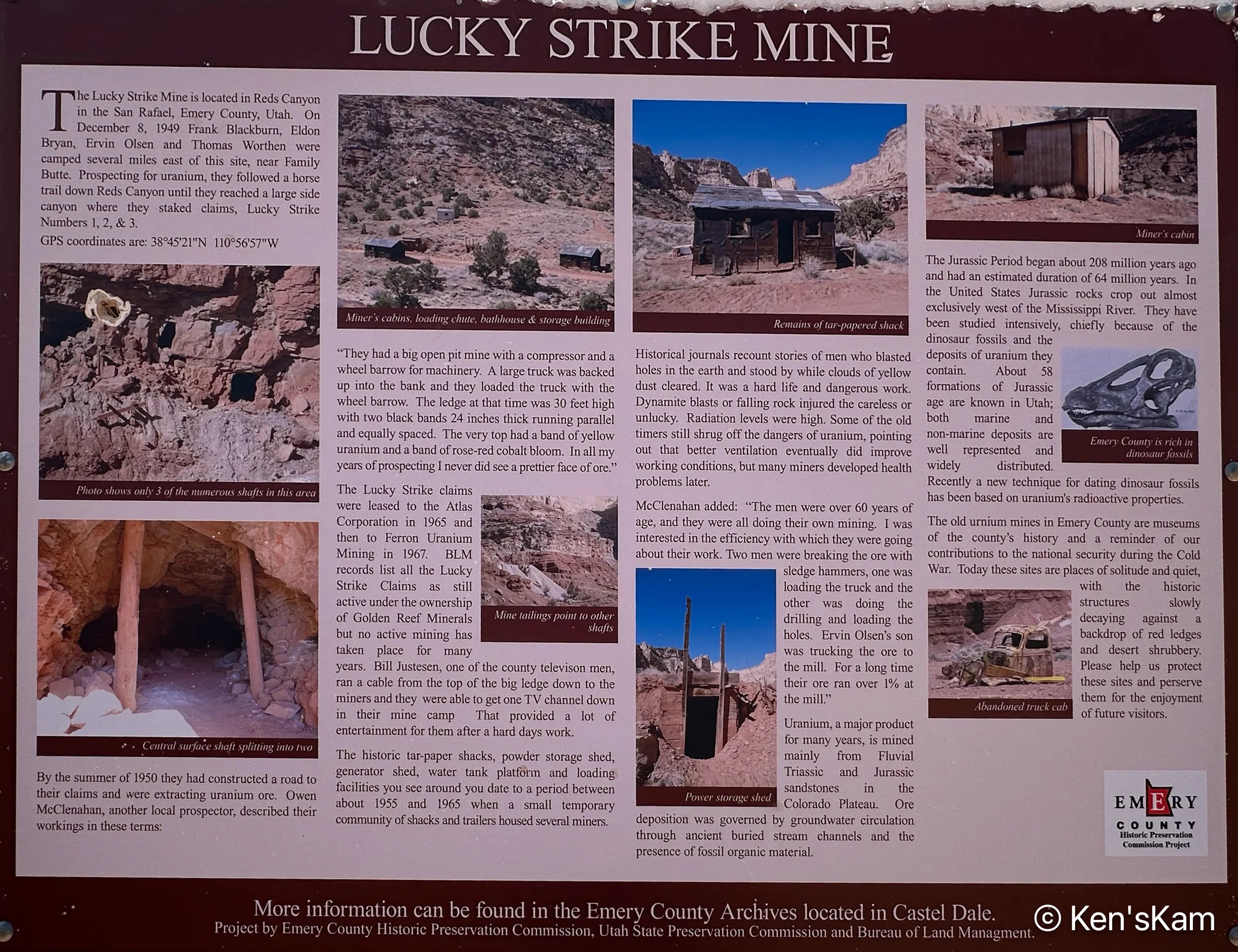
This old shack is at an abandoned uranium mine site called the Luck Strike Mine, which is actually still classified as “active”, even though there has been no activity here for many years. The small structure on the right of this image is a powder (explosive) storage shed.
This sign near the shack give a brief and interesting history of the mine and the lives of the miners who worked the mine, many of whom developed illnesses related to radiation exposure before there were any significant safety regulations regarding such activity.
Most of the photos in this post were made via an iPhone camera.
There are numerous 4 wheel drive roads readily accessible near our first Utah campsite. Portions of these roads do not actually require 4 wheel drive, nor high clearance vehicles, so ordinary passenger vehicles can get to some of the places revealed in this post, unless there have been rains sufficient to make the roads impassable, in which case even 4 wheel drive vehicles should avoid portions of these roadways.
It is spring (or almost) and time for another spring trip with my oldest son. Traveling in the U.S. for outdoor activities in the spring, one always has to consider the weather at potential destinations.
The initial plan this year was to fly into Portland, Oregon, drive to Cannon Beach for photography along the Oregon coastline, knowing that the typical rainy weather along the coast might result in last minute changes, and it did. The forecast for the time interval available for this trip was for cool, rainy, overcast weather every day, which can offer some opportunities for photography, but might not be so pleasant every day. So cancel plan A. Move to Plan B.
Plan B was to go to the same area as last year, where there were still some possibilities to see and photograph in some locales not visited during previous trips. Then a few days before executing Plan B, Plan C came up. Plan C was to explore an area of Utah seen superficially and partially, when passing through on the way to other destinations. Plan C was executed.
I drove two long days to reach the first destination, a first come first serve, free camping area on BLM (Bureau of Land Management) public land not far off of I70 west of Green River, Utah. This area is said to be popular with off roaders and I wanted to be sure to get here to find a campsite before the weekend crowd arrived. As it turned out, while there were a few scattered campers, including those hauling their offroad vehicles, there was no large crowd and I easily found a suitable campsite, somewhat secluded from others.
I shot the sunset panorama standing on the roof rack of my vehicle. If one looks closely, the tops of a few other campers can be seen in this image.
My son met me here to begin our exploration, making this our initial home base. Before he arrived, I had some time to walk around this area, shooting desert scenes with my iPhone. So stay tuned for part 2 to see some of those images.