We retrieved our cameras, after leaving them out at night, programmed to shoot the night sky, in the early morning and proceeded to shoot sunrise photos at Utah’s Little Grand Canyon.
Sunrise Golden Hour, Little Grand Canyon, Utah
It was a cloudless morning, so the sky was bland and the sunrise was not at a good angle to illuminate much of the geological features in and around the canyon. This limited the possible compositions. Perhaps another time of the year might work better for sunrise at this location.
After a brief and limited golden hour sunrise shoot along the canyon, we drove back to The Wedge and shot a few images there. The smoke from a distant wildfire lingers in the canyon, giving this image a “misty/foggy” appearance.
These two Smoky Morning images were shot from the same spot, I just zoomed in a little more and shifted the camera more to my right, eliminating most of the glare from the sun, emphasizing the big round rock in the middle, creating leading line features with the sunlit rocks on the bottom right diagonal and keeping the smoky effect in the canyon.
This concludes my photography (except for the yet to be edited night time photographs) at Utah’s Little Grand Canyon. Now it is time to move on and find another location.
In reviewing a map of the area near our base camp, we discovered a place referred to as Utah’s “Little Grand Canyon”, along the San Rafael River. So we set out to check out that site. Along the way we found other interesting places and sites. This post and following ones will showcase our finds.
The drive to the “Little Grand Canyon” was along maintained gravel backroads, although most of the roadways were washboarded, rocky and rough, but scenic for long stretches with exposed geological features.
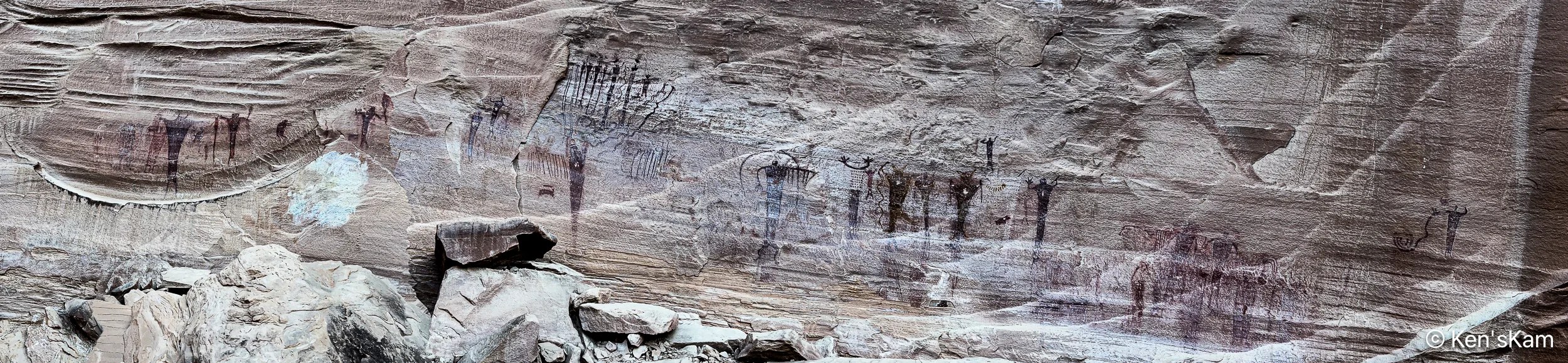
There are a couple of easily accessible Native American artwork panels on rock faces along this drive. One requires walking up a slight incline to reach, but the most impressive one, Buckhorn Wash Petroglyph Panel, has a large parking lot and is literally right at the edge of the parking lot.
The Buckhorn Wash Petroglyph panel is long. Much longer than this panorama might indicate. I made this panorama with my iPhone by walking fast from one end of the panel to the other, trying not to trip and fall on the rocky, uneven surface. I was inspired to do this, after watching my son do it. Otherwise, I might never have thought to do a pano in this manner.
The following images are shots of small portions of the panel, showing details of some of the pictographs.
There are a number of signs placed in front of this panel with information and questions about what these images mean and how newer cultures came along and modified the older pictographs. And, yes, even modern day vandalism. In fact much damage to this panel was partially repaired in 1995.
Information Sign at Buckhorn Wash Petroglyph Panel
Please refrain from defacing such ancient records. These are already fading away due to natural weathering. Don’t accelerate the loss.
It is spring (or almost) and time for another spring trip with my oldest son. Traveling in the U.S. for outdoor activities in the spring, one always has to consider the weather at potential destinations.
The initial plan this year was to fly into Portland, Oregon, drive to Cannon Beach for photography along the Oregon coastline, knowing that the typical rainy weather along the coast might result in last minute changes, and it did. The forecast for the time interval available for this trip was for cool, rainy, overcast weather every day, which can offer some opportunities for photography, but might not be so pleasant every day. So cancel plan A. Move to Plan B.
Plan B was to go to the same area as last year, where there were still some possibilities to see and photograph in some locales not visited during previous trips. Then a few days before executing Plan B, Plan C came up. Plan C was to explore an area of Utah seen superficially and partially, when passing through on the way to other destinations. Plan C was executed.
I drove two long days to reach the first destination, a first come first serve, free camping area on BLM (Bureau of Land Management) public land not far off of I70 west of Green River, Utah. This area is said to be popular with off roaders and I wanted to be sure to get here to find a campsite before the weekend crowd arrived. As it turned out, while there were a few scattered campers, including those hauling their offroad vehicles, there was no large crowd and I easily found a suitable campsite, somewhat secluded from others.
I shot the sunset panorama standing on the roof rack of my vehicle. If one looks closely, the tops of a few other campers can be seen in this image.
My son met me here to begin our exploration, making this our initial home base. Before he arrived, I had some time to walk around this area, shooting desert scenes with my iPhone. So stay tuned for part 2 to see some of those images.
We returned to the area refered to as White Rocks in Southern Utah for an early morning shoot. I switched from the Nikon D850 and 24-70mm lens to the Nikon Z8 and Nikon Z14-24mm for this shoot.
The square shape of the head on this hoodoo looks as if it could have been purposely shaped. Getting this image with that georgeous sky behind it was a bonus.
Square Head from another view point
Maybe those rocks in the foreground are from previous hoodoos here?
This post is a continuation of photography in an area of Southern Utah that is commonly referred to as “White Rocks”. There are many interesting rock features in this area.
I have to admit to cheating a little in the editing of this first image. In the original image there was a big rock where the two in the foreground are now. I found that single, large rock distracting, so I used Lightroom’s AI tool to break that rock into smaller rocks. This tool is often used to remove objects, but it can also modify objects. the tool creates three choices from which to choose at each activation and one can repeat the activation, if none of the choices are desirable. I could have completely removed that big rock, but that did not seem appropriate, so I chose this broken rock alternative, which I think fits better with the other rocks in the “Broken Circle”. Some will object to this blatant modification of a landscape, but I’ve finally gotten to the point of seeing such photography as much as art as in faithfully copying what nature provides. So I’m ok with modifications, within reasonable limits and we have to use our own judgment as to what is “reasonable”.
Geologist refer to these rock features as “hoodoos” or “toadstools”. To me the rock atop the pedestal in the foreground here looks like a toad. So Maybe this is a “Toad’s Stool”.
I titled this “Parent and Child”, but I can also see it as a dog with its tail sticking up. Some people’s pareiodlia may see it otherwise, but in the end it is another of natures marvelous creations, no matter how we perceive it.
I made this second image of “Parent and Child” a few minutes after the first, composing from a different angle. Within those few minutes, the sky in the background had changed significantly due to the windy conditions, illustrating how a minor change in view point and changing environmently conditions can affect a photograph.
A close up of the hoodoo with the pink bonnet in the previous image and a conversion to monochrome, give a completly different interpretation to this scene.
Getting into a position to make this image was not easy. Steep slopes with gravel size rock chips and thin layers of sand over the hard rock surface and other obstacles, made moving around treacherous and positioning awkward.
These hoodoos are the same one presented in individual photos. Grouping these into one shot, I’m imagining a father, child and mother in these rock shapes, all peering down into the valley below.
Another group of hoodoos that look like a family unit. Dad in the background, mom on the right, casting a sideways look at the child in a curious manner.
That’s it for now. Stay tuned for more Southern Utah landscapes,