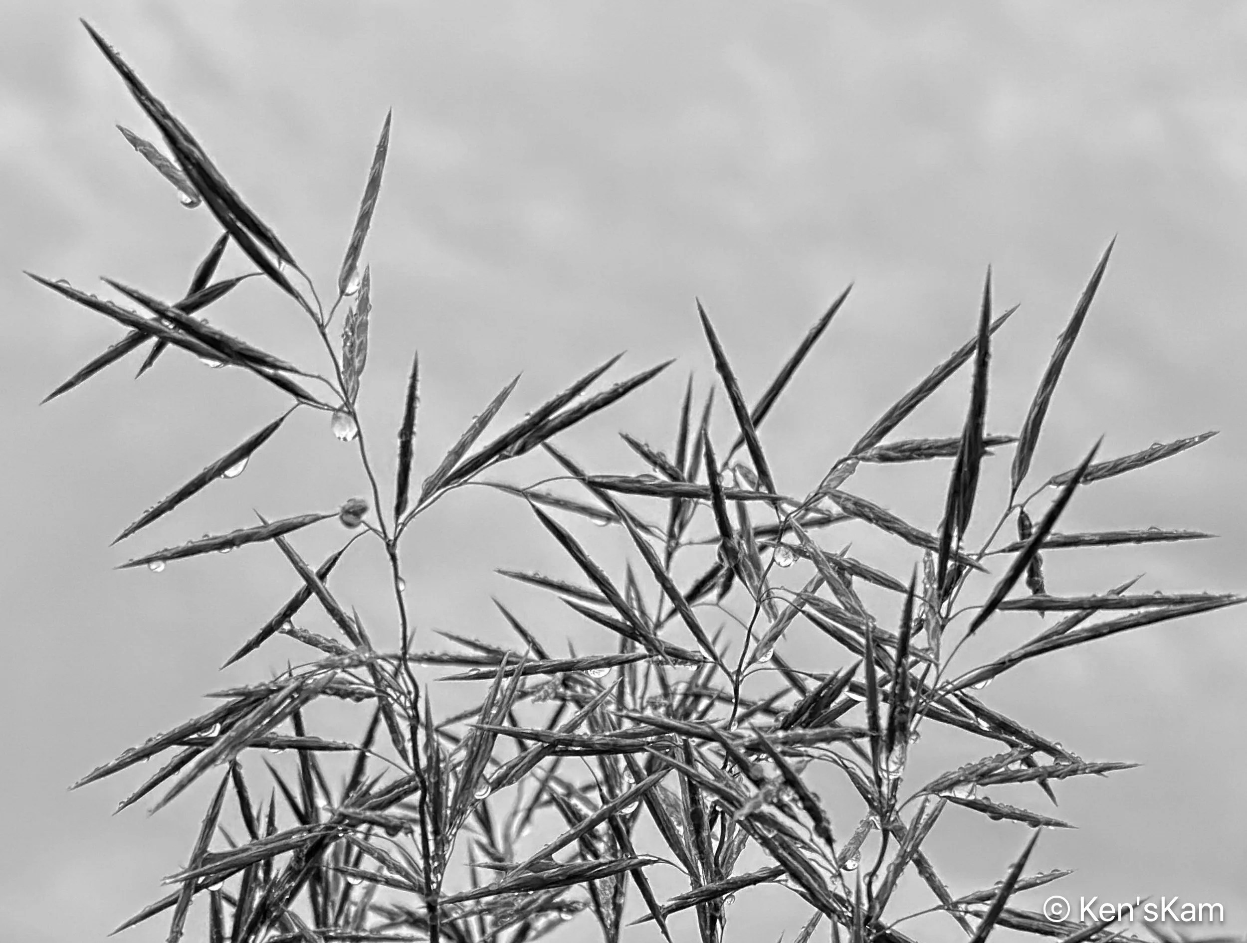
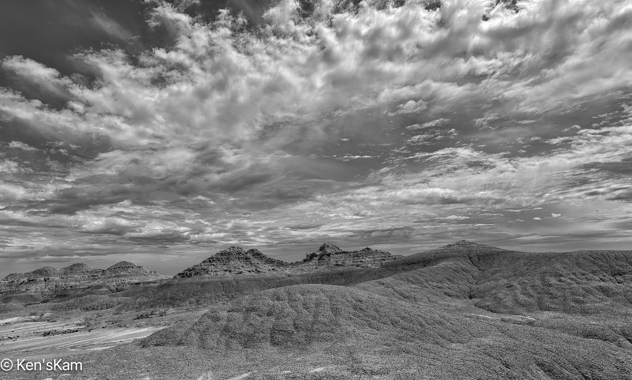
Southern Utah March 2025 – Wire Pass and Buckskin Gulch, Part 1

Wire Pass is a narrow slot canyon, about 3/4 mile long that feeds into Buckskin Gulch, reportedly the longest slot canyon in the world. The trailhead for Wire Pass is about a 45 minutes drive, if the road conditions are good, from White House Campground.

This is a fee area, requiring a small fee for day use. The first time we came here in 2009, the parking lot was small. This area is much better known and much more visited now than it was back then. Now the parking lot is much larger and fenced with a metal bar/pipe type fence. This parking lot is also for the trailhead to The Wave, which requires a permit for access. Permits for The Wave are awarded via a lottery. I have registered for this lottery numerous times, in person and online, over the years, including for this trip, and I’ve never been successful at obtaining a permit.

For photography, the best time to be in the canyon is around mid-morning to maybe mid afternoon. So we did not need to get here super early, but we did want to beat the crowds, so we arrived in time to hike the mile in the sandy creek bed to the entry to the slot by mid-morning. There were already quite a few folks out, but not a big crowd.

It was a cold, but sunny morning. There had been snow fall the previous day, but the dirt road, going south from highway 89 was in fair condition. This road is impassable when it is really wet.

Wire Pass Slot Canyon Entry
The First Obstacle

Just into the entry point, the first obstacle, a twisted, broken tree trunk spans across the slot, requiring either crawling underneath or climbing over. I went under one part and over the other. I don’t remember in which order.

Wedged Tree Trunk

This wedged in tree trunk was high enough on the wall to walk beneath and is an indication of why one does not want to go into such a canyon, when there is a chance of a flash flood.

Wire Pass 1

Wire Pass is a typical slot canyon with varying widths through which to pass, but is never extremely narrow. But it is narrow enough that folks have to stand aside to allow others to pass.

Wire Pass 2
Wire Pass 3
Wire Pass 4

Many years of flash flooding have eroded the walls into nicely contoured features and shapes. Light, which varies through out the daylight hours, from the top of the canyon provides varying color to the rock walls.

To be continued,

Ken


Southern Utah March 2025 – The Nautilus

We were informed about a rock feature not far from our White House Campground by another visitor. So one afternoon we hiked to that feature from our campsite.

The hike was fairly short and relatively easy, requiring about 2/10 – 3/10 of a mile hike on the road into the campground, then another 1/4 mile or so in a sandy, dry creek bed.

The Nautilus

This rock feature is called The Nautilus, due to its twisting opening through a rock. That slope at the base of the hiker is much steeper than it looks in this image and the loose sand in it makes it a bit treacherous to walk up. Then there is another climb out on the other side that is not as steep. [This first image was chosen for Flickr’s Explore Page].

The Nautilus, Lower End
The Nautilus, Looking down the lower slope

This image gives a better indication of the narrowness of the lower section. Climbing up the narrow channel and making the sharp turn can be a little tricky with the slippery sand on the rock. At least this is true for adults. Small kids can easily and quickly navigate the slope and turn. It is easier and safer for us old kids to go around to the top, rather than going through the crevice; but I went through, anyway. I’m told by others that small kids like to slide down through this feature. Old kids might accidentally slide down and through, if they are not careful.

The Nautilus, Lower Wall Details
The Nautilus, View Through

Hugging the wall on the left, it is possible to get a view through to the other side of this twisted rock crevice.

The Nautilus, View from the top side
Island

‘Island’ is a small scene along the dry wash hike to The Nautilus.

Ancients

‘Ancients’ is another image made along the hike to The Nautilus.

Companions

‘Companions’ is an iPhone image of rock features in the walk in tent camping area of White House Campground.

This is the end of this short adventure. Stay tuned for more Utah rocks and landscapes.

Ken


White House Campground and Trailhead

Base camp for my spring 2025 photo outing was White House Trailhead and Campground. This site is on BLM land south of Highway 89, near Big Water, Utah, west of Page, Arizona.

I don’t know why the name “White House”. Maybe it is because of the white rocks at the campsite and all around this area.

When choosing a campsite, I use online apps and websites with reviews and photos from the campsites. I’m nearly always disappointed in the photos. It seems most campers and RVers mostly like to photograph their tents and RVs in a campsite, maybe the facilities and signs, but often don’t photograph much of the area around the campsite.

The White House Campground is not a large one, with only a few sites suitable for RVs; but it is in a beautiful location with massive rock features. There are more walk in tent sites past the end of the road at the campground. The pit toilets are well maintained, too. The campsites are on a first come, first serve basis, but there were plenty of open sites, when I arrived. Payment for the campsites is via an automated kiosk at the site. No need for a check or cash, as in the old days. Now a credit card is all that is accepted and discount cards such as Senior Passes for the National Parks and Public Lands are honored.

Sportsmobile in Campsite

After setting up in my chosen site, I walked around with my iPhone to capture a few images of the area.

Desert Vegetation and Rock Back Drop, White House Campground Area
Tree and Dimpled Rock, White House Campground Area
Curls, White House Campground Area
Long Wall, White House Campground Area
Rock Curves and Layers, White House Campground Area
Boulders from Above?, White House Campground Area
White House Campground Area, Day Use Parking Area in Background
Sand Dune at Base of Cliff, White House Campground Area
Bent Tree, White House Campground
Rock Wall at White House Trail Head and Campground

As one can see this is a scenic area, especially for those with an interest in geology.

This site is a trailhead for a hike to and into Buckskin Gulch, the longest slot canyon in the world.

Stay tuned for more Utah landscape photos,

Ken

March 2025 Road Trip

It seems that my March road trips always involve some sort of drama. This year was no different. The first day of my trip was extremely windy. Driving through the Texas Panhandle towards Amarillo, I held my speed down to 55-65mph due to the strong, steady and gusting winds. In spite of my reduced speed, the headwinds resulted in the lowest fuel economy that I have experienced in my Sportsmobile, which does not get very good mileage to begin with.  I saw 4 eighteen wheelers laying on their sides along the way and one other sizeable trailer of some sort on its side. The crosswind assist software in my vehicle kicked in at least once.

I made it to Amarillo, safely, where I stayed overnight.

The second day of my journey was better. It was still windy, but not so much as the day before. Although, I did drive through intermittent rain, sleet and snow.

Light Snow Begins, iPhone Photo
Low Visibility, iPhone Photo

The snow was heavy enough at times to reduce the visibility, but not to such an extent as to inhibit travel.

I-40 East of Albuquerque, NM, iPhone Photo

One of my favorite portions of I-40 west of Amarillo is that approaching Albuquerque, NM, with its gently rolling hills and scenic views. West of Albuquerque, near Grants and Gallup are attractive red rock outcrops which are another portion of this drive that I like.

I spent my second night in Gallup, NM, where the temperature got down to about 17 degrees overnight.

Travel the third day was much more pleasant, mostly sunny and clear. Although, from my overnight location, my directions took me along many miles of rough back roads on Native American lands, where the speed limit was 25mph for miles, before finally getting up to 35mph for many more miles. I felt like I was speeding, when I finally got into a 55mph zone.

Much of my travel on this third travel day in New Mexico and Arizona was through Native American lands, where the speed limits are often quite lower than elsewhere, but the scenery is often beautiful for mile after mile.

Straight On, iPhone Photo
Church Rock. iPhone Photo

I know that I’ve driven this route previously, but maybe it has been so many years that I don’t recall the scenes. For many miles, I could see a big rock feature far in the distance. Sometimes as the road changed directions, I lost sight of it for miles; but eventually my route took me right past it. So of course, I had to stop, hike up a hillside to photograph it. I later learned that this feature is called “Church Rock” and the creek just west of it is “Church Creek”.

Sometimes the sky puts on a show with a display that has to be captured.

Cloud Burst, iPhone Photo

There are always so many sight in route that I would like to photograph, but if I stopped for everything I want to photograph, I would never make my destination in the time interval alloted for travel.

So this is it for my few photos in route.

Stay tuned for more landscape photos,

Ken


Lake Tahoe, August 2024, Part 1

From Yosemite we traveled to South Lake Tahoe, where we stayed for a couple of nights before hitting the road for the long drive back home. The drive to Lake Tahoe was a scenic one with the first part a long drive through the western portion of Yosemite that we had not yet seen; although, that portion of Yosemite is not nearly as scenic as the eastern portion.

My GPS changed our route after we exited the park, supposedly due to a road closure on the original route.  Maybe this was a good change, since I had seen portions of the original route during a visit to that area earlier in the year.  So I got to see some backroad areas that I would not have seen, otherwise and a long portion of the drive, coming down from a higher elevation, was on a steep, curvy road where the road was visible for a good distance ahead and the steep hills with the roadway winding through was a scenic, if slow drive.

I had done a little online research of the Lake Tahoe area and had a few places in mind for photography.  My first plan was to photograph sunrise at a site referred to as “Bonsai Rocks”, because of the little trees growing on big boulders in the edge of Lake Tahoe.  I only had indications on a map of where these rocks were located and some descriptions of where to park and follow a trail to the “beach”.  So I got up early in the morning intent on going out to find these big rocks with the little trees.  But I suddenly realized that I would be wandering around in the dark trying to find a place that I was not sure how to find and I decided that might not be the safest thing to do, so I went back to bed.

After breakfast, my wife and I headed out to drive around Lake Tahoe and I planned to find those rocks along the way.  I used my GPS directions on my phone to navigate to the place marked as “Bonsai Rocks”, finding that the destination was a pullout along the highway that skirted around the lake.  I had visualized the roadway being adjacent to a beach area, where one could see those rocks from the roadway.  That is not what I found. There was no sign at the pull out designating it as an access point for Bonsai Rocks, although I saw numerous trails going down the steep bank of the lake.  So I grabbed my camera and began working my way down one of the trails.  There were crisscrossing trails going down towards the lake, but no markings.  Maybe these trails have been created over the years by people like me wandering around in this area trying to find those Bonsai Rocks.  Not only were the Bonsai Rocks not visible from the roadway, they were mostly not visible from the trails, until one lucked upon the correct one and got close to the lake.  I initially went the wrong way, finding some big boulders in the edge of the lake, but not the ones I was looking for.  So I kept exploring the trails until I spotted the Bonsai Rocks.

August 15, 2024
Kayakers on Blue Water

All this wandering around these trails in the daylight made me realize I made the right decision not to try this in the dark.  Had I had time to scout the area first, I could have marked a trail digitally and followed that digital route or I could have probably had enough early morning pre-sunrise light to navigate by, if I had known where to go.

Not sure that I would actually find the Bonsai Rocks, I made photos of the lake, whenever I could do so along the maze of trails.  I even came upon a young couple preparing to swim or sun on some of the near shore boulders and they could not tell me where the Bonsai Rocks were located.

August 15, 2024
Boaters on Lake Tahoe
August 15, 2024
Boulders in and around Lake Tahoe
August 15, 2024
Lake Tahoe and Shoreline
August 15, 2024
Dead Tree and Lake Tahoe


August 15, 2024
Bonsai Rock

Finally, after much wandering around and working my way northward, I spotted the Bonsai Rocks, which were covered by people, as I had expected from seeing so many kayakers and boaters on the lake.

To be continued,

Ken


Yosemite National Park – Part 7

This post will wrap up my photography in Yosemite National Park, shooting the sunset golden hour at Yosemite Valley along the Merced River.

Aug13, 2024
Yosemite Valley Sunset Golden Hour 1
Aug13, 2024
Yosemite Valley Sunset Golden Hour 1A
Aug13, 2024
Yosemite Valley Sunset Golden Hour 1B
Aug13, 2024
Yosemite Valley Sunset Golden Hour 2
Aug13, 2024
Yosemite Valley Sunset Golden Hour 2A

I shot as the shadows creeped upward on the rock formations, pushing away the golden sunset light, so there are subtle differences between some of these images.

Aug13, 2024
Yosemite Valley Sunset Golden Hour 2B
Aug13, 2024
Yosemite Valley Sunset Golden Hour 3
Valley View, Yosemite Valley

The final image is near the very end of golden sunset hour, looking up river.

This wraps up my time in Yosemite.  Until next time,

Ken

Yosemite National Park – Part 6

While waiting for sunset golden hour at the edge of the Merced River at Yosemite Valley, I continued to make a few iPhone images of the scene in front of me, experimenting with compositional variations.

Yosemite Valley, iPhone Photo
Yosemite Valley 3, iPhone Photo

When the scenery is so marvelous, it is difficult to be satisfied with just a few image variations.

Bridal Veil Falls, iPhone Photo

Bridal Veil Falls is visible in the distance across the river from this location and is seen in many of my compositions here, but usually as a small part of the image.  I zoomed in to get this shot.

Yosemite Valley 4, iPhone Photo
Golden Hour, iPhone Photo

Looking ahead to the next post with these last two images, after shooting the golden hour with my DSLR, I made a few images with my iPhone as the golden hour ended.

Golden Hour Reflection in Merced River, iPhone Photo

Stay tuned for my final shoot in Yosemite,

Ken


Yosemite National Park – Part 5

For my final evening shoot in Yosemite, I decided to check out locations in the valley, finally choosing the Yosemite Valley View Point.

I arrived early to be sure I could find a place to park in the small pull out and walked around the area with my iPhone scouting shooting locations before I retrieved my tripod and DSLR from my vehicle.

Yosemite Valley, iPhone Photo

I also experimented with test compositions, using my iPhone camera to do so.

Yosemite Valley 1, iPhone Photo
Yosemite Valley 3, iPhone Photo
Merced River, Yosemite Valley
River Rocks, iPhone Photo, Monochrome

I finally picked a place at the very edge of the Merced River at the parking lot.  I would have like to have shot from farther done the river, but there were people sitting where they would be in most of my shots and lots of visitors wandering around that area, too.  So I figured shooting across the river and back up the river from the parking lot area would avoid most such disturbances.

Rocks and Reflection, iPhone Photo

I set my tripod legs on rocks in the edge of the river and I had a rock to sit on while I waited for golden hour.  While I waited, I made more images with my iPhone and a few test compositions with my DSLR.

More later,

Ken


Yosemite National Park – Part 4

After my early morning photography, my wife and I returned to the park to drive to Glacier Point. It is a long drive, but well worth the time, as the views from the stops along this route are spectacular.

Half Dome, Sub Dome, Vernal Falls and Nevada Falls – iPhone Photo

I shot with both my iPhone and my DSLR with 24-70mm lens and 80-400mm lens with an extension tube. It was not optimal time for the best light for landscape photography, but this was the only opportunity I would have to be here for the foreseeable future, so I captured many images while I could do so.

Half Dome and surroundings, iPhone Photo
Aug13, 2024
A View from Glacier Point

Sub Dome blends into the background in some of these shots, but it is just above and to the left of the two waterfalls, which might appear small in these images, but those are quite large.

Sub Dome and Waterfalls, iPhone Photo

Sub Dome towers above Vernal Falls and Nevada Falls.

Aug13, 2024
Sub Dome, Vernal Falls and Nevada Falls in Monochrome
Aug13, 2024
Nevada Falls 1
Aug13, 2024
Vernal Falls
Aug13, 2024
Half Dome
Aug13, 2024
Half Dome, Monochrome
Aug13, 2024
Sub Dome and Nevada Waterfall


Aug13, 2024
Sub Dome and Waterfalls
Aug13, 2024
Nevada Falls and Bridge

The bridge over the stream feeding Nevada falls and the many people around the top of the falls only became apparent upon using the 80-400mm lens.

Aug13, 2024
Nevada Falls 2
Aug13, 2024
Vernal Falls 2

There were some people standing near the top of Vernal Falls in this image, but I removed them in Lightroom. I think there may be other people in the far background, but I did not attempt removing those small, fuzzy objects.

These images are representative of the views from Glacier Point and Washburn Point overlooks.

Thanks for following,

Ken


Yosemite National Park – Part 3

After a sunrise shoot at Tunnel View, I stopped at the parking area for Bridal Veil Falls.  The falls can be seen from the parking lot and there is a short trail that gets one much nearer the falls.  The trail is easy, but is slightly uphill most of the way, so it does take a little effort to hike.

Aug13, 2024
Bridal Veil Falls 1

I switched back to my 24-70mm lens before hiking the trail, but soon realized that the 80-400mm lens would have allowed me to capture close up images of details in the tall, slender waterfall.

Aug13, 2024
Bridal Veil Falls 2
Aug13, 2024
Bridal Veil Falls – Wide 1

The image above gives an idea of how far away the end of the trail viewing area is from the falls.  This view covers the entirety of the falls from top to the bottom most part that I could see, including small portions in the bottom left, but excluding the sky to avoid exposure difficulties. I could have gotten a little closer, as a few people do, by climbing beyond the viewing area border, but I elected not to do so.  One can easily see how a big lens would be useful for isolating smaller portions of this waterfall.

Aug13, 2024
Bridal Veil Falls

This long, slender waterfall does not fall straight down, but swings back and forth across the rock face.  Maybe with a heavier water flow it might fall in a more linear fashion, but this meandering path creates more interesting features and that “veil” appearance.

Aug13, 2024
Bridal Veil Falls –  Wide 2

This wider angle view gives a better indication of the local environment.

Aug13, 2024
Bridal Veil Falls 3

If I had brought my big lens, I would have zoomed into features such as the ledge in the bottom portion of the image above.

Aug13, 2024
Bridal Veil Falls – Wide 3
Aug13, 2024
Bridal Veil Falls – Wide 4
Aug13, 2024
Bridal Veil Falls 4
Aug13, 2024
Bridal Veil Falls 5
Aug13, 2024
Bridal Veil Falls 6
Aug13, 2024
Bridal Veil Falls 7
Aug13, 2024
Bridal Veil Falls – Wide 5
Aug13, 2024
Bridal Veil Falls 8
Aug13, 2024
Bridal Veil Falls 9
Aug13, 2024
Bridal Veil Falls 10

Some of the close up look images are extracted from wider angle ones by cropping the images, which I’m sure readers have realized.

That’s more than enough for now.  Thanks for following,

Ken